
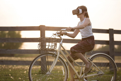
The study "Virtropolis" uses StreetMind in combination with virtual reality to assess spatial learning and navigation in a novel environment.
The study plans to assess ~40 adult participants in Mannheim (Germany), starting February 2024.

How do we learn to navigate through a novel environment? And how does our everyday experience in this environment influence how well we learn and memorize the environment?
In this study, we use virtual reality mimicking a real environment through which participants must learn to navigate through and memorize objects and their locations. The StreetMind app is used for 4 weeks to characterize participants regularly visited locations and travelled paths and their emotional connection to the novel environment in the real environment. After the four weeks, participants come back to the lab to perform the same navigation and spatial memory tasks in virtual reality as before.
À propos de l'auteur

Sur le même sujet:
Commentaires
By accepting you will be accessing a service provided by a third-party external to https://www.streetmind.eu/
Télécharger l’appli
Télécharge l’appli gratuite pour ton appareil Android ou ton iPhone depuis l’App Store!S’inscrire
Il te suffit d’une adresse email pour enregistrer ton compte d’utilisateur sur la plate-forme.Commencer!
Après cela, tu es déjà connecté à l’appli et tu peux commencer tout de suite!Ce site web n'utilise aucun traceur externe, aucune analyse, uniquement des cookies de session et respecte votre vie privée.